 Catálogo de datos del IEO
Keyword
Tethys II
4 record(s)
Type of resources
Categories
Topics
INSPIRE themes
Keywords
Contact for the resource
Provided by
Years
Formats
Status
-
Studying the Messinian Salinity Crisis on the Balearic promontory and using its markers to assess post-crisis vertical movement and the reactivation of the region. 1) Fine-scale continuous mapping of evaporites from land to the deep basin in order to answer the following question: What is the spatial-temporal variability of evaporites of the Balearic Promontory (evaporites on land, very thin or thick evaporates at sea)? 2) Using the Messinian as a marker of syn- and post-MSC deformations; isolating recent movements from previous deformations and quantifying them in order to reproduce the paleo-bathymetry and paleo-connections during the crisis. Were the evaporites in shallow basins continuous with evaporites in deeper basins before the recent deformations? The related project is 'Action Marges', Mediterranean study site.
-
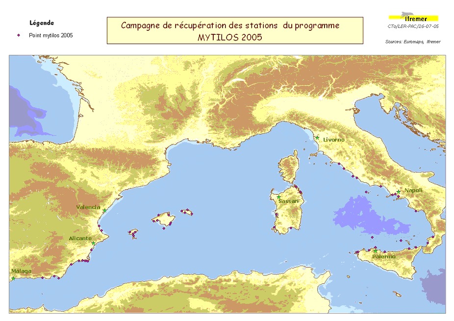
Assessment of chemical contamination in coastal water masses (Spain, France, Italy), using artificial stations of mussels and passive sensors. The MYTILOS 1 cruise aimed to use the RINBIO network methodology around the western Mediterranean. Experiments done in the French Mediterranean since 1996 by IFREMER will be extended to Spanish and Italian Mediterranean coasts on the basis of a standardized protocol. The data will supplement those obtained in 2004 during the RINBIOC1 cruise by including the islands of the western basin, the south of Spain and Italy. In addition, the results will be used to complement the chemical contamination budget made in the framework of the European Water Framework Directive's implementation. The survey was based on 2 major actions: 1) Retrieving artificial mussel bed stations immersed in March with R/V l'Europe along a shoreline between Malaga (Spain) and Rome (Italy), including the Balearic Islands, Sardinia and Sicily. 2) Gellyfish-type "passive" sensor stations were deployed along with some of the artificial mussel bed stations. This falls under the MYTILOS project.
-
Understanding the role played by the combined physical-biogeochemical dynamics at (sub)-mesoscales in exchanges of matter and energy between coastal and open sea areas. The LATEX strategy is based on selective and combined use of numerical modelling and in situ observations (Lagrangian floats, SF6, shipboard ADCPs, ADCP moorings, satellite images, gliders and coastal radars). The main objective of LATEX is to study the impact of an eddy structure at (sub)mesoscale, which is chronically present in the western part of the Gulf of Lion, in interaction with the North Mediterranean current(NMC)on trends in the distribution of conservative tracers and biogeochemical properties. Thanks to this strategy, LATEX should provide answers to the following questions: - Is this type of structure likely to significantly affect the horizontal transfer of matter between the continental shelf and the NMC? - What are the consequences for biogeochemical cycles of the structure's interaction with the NMC? - How do CO2 concentrations evolve within the eddy throughout its life cycle? - How does this type of (sub)-mesoscale coastal eddy act in structuring of plankton communities and the variability in primary production observed in the study zone? - Are the amounts of matter transferred by (sub)-mesoscale structures significant with respect to that displaced by the general circulation on seasonal and annual scales? The related project is called LATEX (LAgrangian Transport Experiment).
-
<p style="text-align:justify">The main objective of the observing system MOOSE is to monitor the long-term evolution of the north-western Mediterranean Sea (over more than 10 years) in the context of climate change and anthropogenic pressure in order to detect and identify the trend and environmental anomalies of the marine ecosystem. The MOOSE network aims to establish an integrated and multidisciplinary system in the Mediterranean Sea in accordance with the objectives of the national MISTRALS program (HyMeX, MeRMEX and ChARMeX). The MOOSE system is supported by national institutes (CNRS-INSU, French Ministry of Higher Education and Research) and involved different partners (Universities, IFREMER, Meteo France).</p> <p style="text-align:justify">The MOOSE network includes "multi-scale" measurement capabilities to accurately document the broad spectrum of hydrodynamic processes already identified (large scale eddies, mesoscale eddies, biogeochemical provinces). High temporal resolution measurements are obtained from fixed observatories (moorings, buoys) but their spatial distribution remains insufficient. Spatial variability is of the same order as temporal variability and understanding the evolution of this basin as a whole implies being able to dissociate both. Synergy with other strategies (ships, floats, gliders) is essential for the establishment of an observation network in such a system. To address the issues identified by MOOSE, two key areas of the north-western basin have been identified:</p> <ul> <li style="text-align:justify">The central and western part of the Ligurian Sea, which constitutes a homogeneous system isolated from direct coastal inputs by rivers and where atmospheric inputs are predominant (DYFAMED and ANTARES). It is also one of the entrance passages of the Intermediate Levantine Water (LIW) in the north-western Mediterranean basin.</li> <li style="text-align:justify">The central area of the Gulf of Lion where winter cooling leads to vertical mixing over 2000 m and sometimes to the bottom. The LION site (42°N 5°E) is ideal for studying the variability of winter convection to better understand mixing processes and dense water formation. It also characterizes the variability of the deep particle flow.</li> </ul> <p style="text-align:justify">Currently, fixed observation at these sites is carried out by six moorings:</p> <ul> <li style="text-align:justify">The Planier and Lacaze-Duthiers moorings composed of sediment traps and T/S sensors and current meters, for dense water cascading and particle export studies. These moorings have been set up since 1994 and managed by CEFREM.</li> <li style="text-align:justify">The LION mooring, consisting of a large number of T/S sensors, current meters, and two oxygen sensors, is in the Gulf of Lion convection zone. It has been deployed since 2007, and is managed by CEFREM and LOCEAN. A sediment trap near the bottom has also been present for 2 years in this area (LIONCEAU mooring). The latter will be integrated into the LION mooring in 2019.</li> <li style="text-align:justify">The ANTARES mooring is located in the North Current off Toulon and equipped with T/S sensors, current meters and oxygen sensors to quantify the bacteria activity and organic matter remineralization process in a deep marine environment. It exists since 2004, it is managed by the M.I.O. and the CPPM (Marseille). This mooring is part of the ERIC EMSO since 2017.</li> <li style="text-align:justify">The DYFAMED mooring, in the Ligurian Sea, equipped with sediment traps, T/S sensors, current meters and oxygen sensors to monitor the evolution of the water column, the impact of atmospheric dust deposition and marine particles export to deep waters. It exists since 1988, it is currently managed by the Oceanological Observatory of Villefranche-sur-Mer. This mooring is part of the ERIC EMSO since 2017.